These pages look at the Southern Wey and its tributaries, section by section, from source(s) to the confluence with the Alton branch at Tilford. Each section is accompanied by a map showing points of historical and natural history interest, as well as roads, bridleways and footpaths.
Historical information on the maps is generally based on the large scale Ordnance Survey maps of the 1860s and 1870s.
Although good views can be had of the sites listed - in many places from footpaths and roads - much of what is recorded here is on private land. The Trust can often help in gaining access to such areas.
These pages give a brief view of the river, picking some sites and stories. You will be able to follow a 'trail' of information points, or simply dip in as you come to them.
Look out for the pathway markers as you explore.
Page 1
From here on downstream modern farming methods have resulted in a degree of uniformity to the riverside meadows. There were undoubtedly watermeadows throughout this length, but unlike those further upstream, they were easily adapted and continued in use as unwatered grazing, or for hay and silage. Any items of stonework such as stops or hatches have been removed to facilitate ploughing which has in turn obscured the ridges, furrows and carriers though some are visible using the LIDAR view.
We are however very dependent on historical records for evidence of past use. This is an area which has yet to be fully researched.
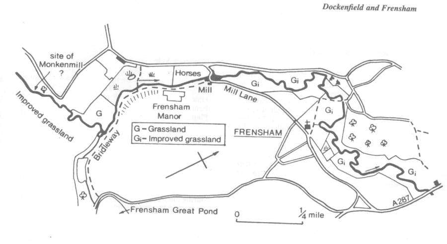
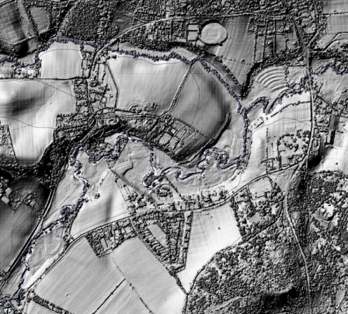
LIDAR view of Frensham Mill to Millbridge
Monkenmill
Little is known of this one time mill site on the Wey at Dockenfield. It is not shown on any of the early maps nor mentioned in local history books, but because of its geological position on the boundary of the Royal Forests of Alice Holt and Woolmer, it is included in records of the perambulations in 1171, 1300 and 1635. These are little more than lists of landmarks through which the boundaries passed, but they enable us to position the site between Huntingford Bridge and Frensham.
The name Monkenmill is significant, for the mill belonged to, and was probably built by, the Monks of Waverley Abbey in the late 12th century. The 1839 tithe map and award clearly identifies an area of land as formerly belonging to Waverley Abbey and provides further clues in field names indicating the mill was a fulling mill.
Between Wishanger and Dockenfield there is a point where the river widens and appears to flow over a low weir or sill. Until further information comes to light this is the most likely candidate for the location of the mill-site.
Frensham Flour Mills
Over the centuries flour was ground at a number of sites in Frensham. The oldest site in the village was also the last to close, in 1926. In the 16th and 17th century a mill operating close to Frensham Pond Hotel used the pond for its head of water. The ponds have a history of their own; they were artificially created as commercial fisheries from the 13th century. Another site of milling may have existed near the former hotel "Mariners" at Millbridge.
Further along before Little Pond outfall joins the river, there are traces of watermeadows seen in the LIDAR view where 'unimproved grassland' is marked in the diagram.
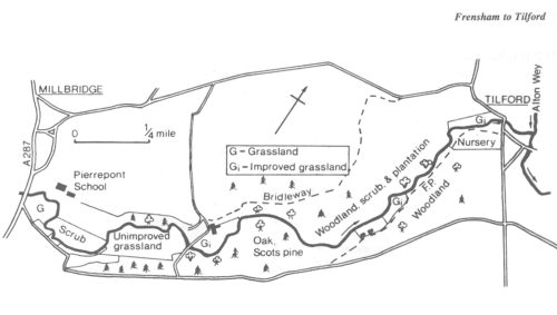
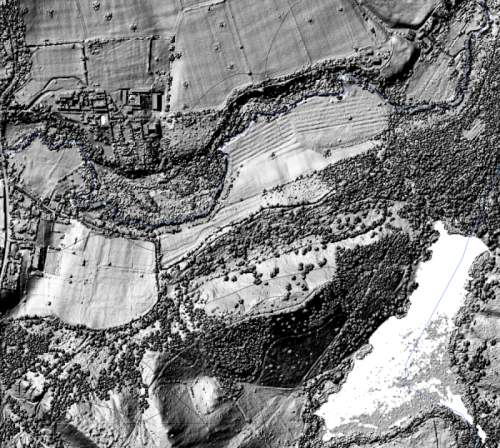
LIDAR view between Millbridge and Little Pond (which shows as white in the LIDAR view)
A historical view of Wishanger and Frensham Pond is given in "Headley's Past in Pictures"
Mellow Farm at Dockenfield used to be known as Lower House Farm (not to be confused with the other Lower House, near Headley Mill).
Actively farmed today, these two farms at one time had extensive water meadows. There are remains of two large sluices, one on the Slea at Trottsford Farm, the other on the Wey at Mellow Farm, and a substantial hatch on one of the carriers. There are also clear ridge and furrow patterns on several of the fields.
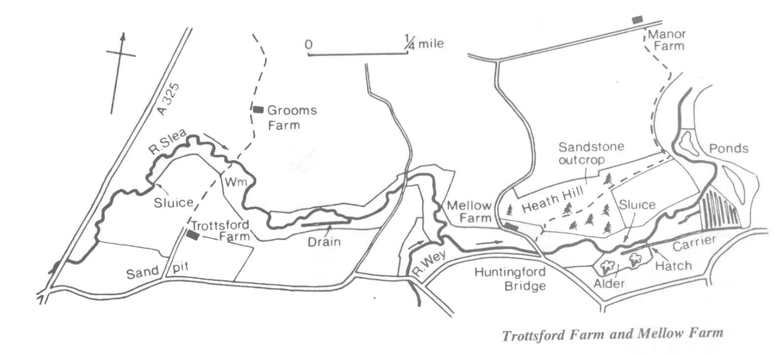
Because the fields have remained in use two effects are noticeable — the pattern of ridge and furrow is more noticeable but most of the stonework has disappeared and the outline of the carriers themselves has become blurred as a result of ploughing. The LIDAR image below clearly shows the features of this part of the river valley.
Mellow Farm can be considered to be the boundary between the upstream and downstream reaches of the southern Wey. The character of the river differs from the upstream reaches, not only is it bigger and slower but the banks are high and steep and the adjacent meadows much drier. This suits modern farming techniques which in turn determined the nature of the landscape.
Most of the meadows are resown with grass at periodic intervals and cut for silage. Wildlife interest is concentrated on the river banks themselves which have a flora interspersed with agricultural weeds such as Teasel, rarely found further upstream. The riverbank flora also reflects the drier conditions of the higher banks.
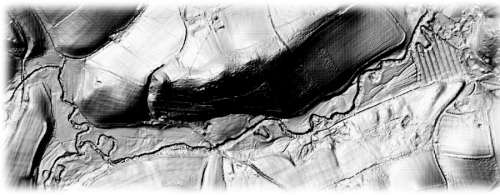
LIDAR view of the stretch by Mellow Farm showing oxbows and the watermeadows
A historical view of Huntingford Bridge and environs is given in "Headley's Past in Pictures"
Barford Mills
At one time there were three watermills in close proximity on a small tributary of the Wey forming the Surrey-Hampshire border between Churt and Headley. All three have been demolished, leaving 2 millhouses and cottages. The oldest mill was the middle one, which milled flour up to 1930. The upper and lower mills were paper mills from the 1730s.
For part of the 19th century these mills belonged to the Warren family, owners of the Bramshott Paper Mills (Passfield and upper Standford). Attractive ponds survive.
Whitmoor Vale
This narrow and deep valley on the county border near Churt is served by the same stream on which the Barford Mills lie. The stream rises near Hindhead and flows NNW to feed Frensham Great Pond. Three farms, Field House, Symondstone and Plaster Hill, operated watermeadows, as indicated by sluices and carriers shown on old OS maps.
Churt
In 1572 a Churt farmer called Luffe paid rent for floodgates — were these for watermeadows?
A meadow adjacent to Crosswater Barn in Churt was irrigated up to 1939. Drainage work in this area during the second world war altered the flow and the watercourses were allowed to collapse.
At Headley Park, among a tangle of alderwood and ivy is the shell of an unusual hexagonal building. The river Wey, slow and deep here, passes by on one side while on the other is a dry channel, almost as wide as the river but lined in places with brick which was the mill leat — over a quarter of a mile long.
The origins of this mill are obscure. A survey of Headley in the 1550s mentioned 5 mills but omitted this one, presumably because it lay in Broxhead Manor and the survey only covered Bishops Sutton. There is, however, a mill recorded at Broxhead in 1086 (Domesday). It seems therefore that this was a manorial mill attached to the original manor house at Headley Park. The mill produced flour until the 1890s.
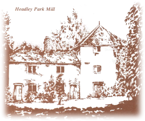
In 1904 a dynamo was installed, driven by the water wheel to provide Headley Park House with pumped water and electricity. This arrangement operated until 1939 when the machinery was dismantled. The building housed a generator for some years afterwards. There were at one time two cottages attached to the hexagonal structure which probably housed the miller when the mill was operational, and estate workers later on. These were demolished post-war, probably for building materials.
A fire in the 1960s destroyed the roof of the mill itself, since when the shell has remained derelict. In 1985 the RWT excavated the mill leat to reveal much of the brick lining intact.
There are watermeadow remains on the opposite bank amongst the woodland.
A historical view of Headley Park is given in "Headley's Past in Pictures"
The Slea and its tributaries originate in part from the chalk beyond Selborne and in part from the base-rich upper greensand. The surrounding countryside is actively farmed and some watermeadow remains can be traced on what is now pasture.
The major exceptions are the areas of Ministry of Defence land known as the “Slab”, the “Warren”, and Shortheath Common — areas of acid heath, bog and woodland similar to the Holly water valley. All three are of major biological importance.
The Oakhanger Stream is a tributary of the Slea which rises at Selborne and joins the Slea near Kingsley. There were extensive watermeadows along most of its length. Today the meadows are used as pasture for cattle.
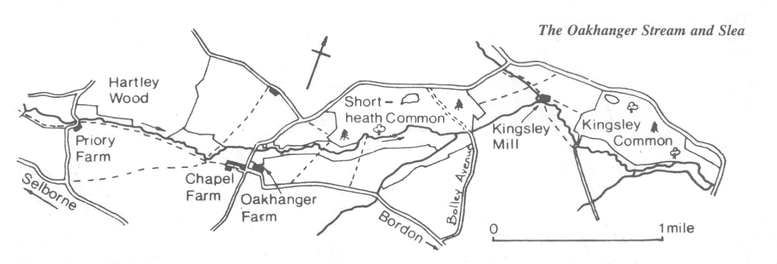
The watermeadows on the Oakhanger stream stretched from Priory Farm, near Selborne, downstream as far as Bolley Avenue. The quantity of water available must have been small, but sluices exist at Priory Farm and Oakhanger Farm — the latter is very substantial.
In 1663 Sir Nicholas Steward (or Stuart) Lord of the Manor of Hartley Maudit was presented at the manorial court of Oakhanger for diverting water from the Oakhanger Stream between Hartley Wood and “Oakhanger Lands” “to the grave hurt” of the Lord of the Manor of Oakhanger. Sir Nicholas defied the court and in 1683 was sued by one William Christmas, gent., a tenant of the manor, at Winchester Assizes.
A verdict was given for Christmas yet in 1691 Sir Nicholas is back in court having diverted the river between “Hartly Wood and the lands of the Lord of the Manor and a part of the same called Pryors Farm.” Sir Nicholas was said to have made a ditch with the intention of diverting the water — almost certainly a reference to watermeadows.
In 1660 an agreement was made between John Hooke of Bramshott and James Bridger the Elder of Tunford (Oakhanger) and his son. Having sold 2 acres of land, Hooke wanted access in order to repair and maintain his watermeadows: “... it shall be lawful to enter said meadow with servants and workmen to repair, amend, maintain and keep the floodgates which are standing upon the river against the meadow ...”
Downstream of the Lindford road bridge the right bank meadows clearly show rush-lined furrows indicating former watermeadow drains. A sluice here used to supply the Headley Wood meadows, but no trace remains.
From Broxhead downstream as far as Headley Park (The Lithuanian Club) the river flows through the Headley Wood Estate, a mixed sheep and arable farm. Access is limited to a bridleway which used to cross the river near the farmhouse but which has now been re-routed to pass over a former watermeadow aqueduct or “arch”. The aqueduct, a Scheduled Ancient Monument, is a single span structure similar to that at Radford but with a rather flatter arch.
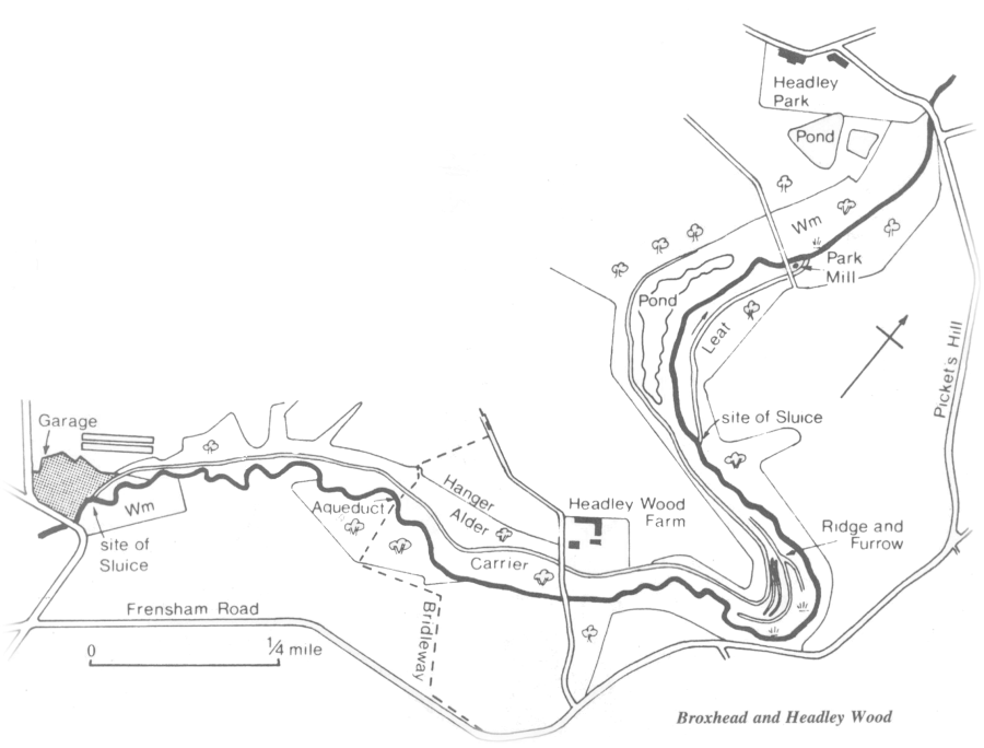
The slopes of the valley are cultivated but the valley bottom watermeadows are now overgrown with alder and willow. There are indications that the alder has been coppiced in the past. The watermeadow carriers and drains are still evident and are shown on many relatively recent maps. It is probable that they fell into disuse at much the same time as elsewhere but have remained undisturbed.
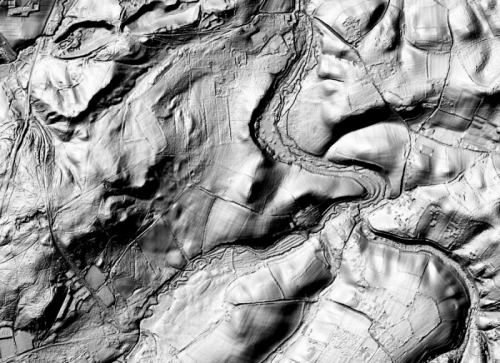
The LIDAR image of this area clearly shows these features. Note that the pond and areas of lying water show as 'flat and angular' due to the reflections from the water.
Watermeadow Farm
Known as Lower House Farm in the last century the upper watermeadows were fed from Headley Mill pond. Today they are disused and a mixture of wet grassland and scrub.
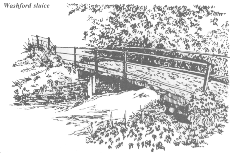
Further downstream below Washford Bridge the meadows have been filled. On the left bank is a school playing field. A sluice remains as evidence that watermeadows once extended further downstream. The River Deadwater joins the Wey at this point.
A historical view of this part of the river is given in "Headley's Past in Pictures"
The Arford Stream is a small tributary of the Wey which rises from springs in Fullers Vale, Headley, and flows through Arford to join the main river at Headley Wood.
In 1987 an important document came to light in the Muniments Room at Guildford. Dated 1806/7 and with an accompanying map it was an agreement between neighbouring landowners on the Arford Stream downstream of Arford village.
That map shows watercourses and an aqueduct — referred to as an “arch” — and appears to have been drawn up to settle a legal dispute concerning the use of the river and the agreed times of watering.
“It is agreed . . . (that) Edward Benham shall . . . make use of the water from the watercourse hatch . . . (through his neighbours land) ... to his Mead called Benham’s Mead or Bilfords Mead during the first seven days of every calendar month without interruption, and that John Willoughby (his neighbour) shall make use of the water over his new arch from the watercourse hatch ... to water part of Curtis Farm the next seven days in every month.”
As well as watering meadows, this was to allow for a water supply to a sheep wash.
Until very recently (2015) Headley Mill was one of the last few watermills anywhere in the country to be working for its living. It stands in its own Conservation Area adjoining the more recent River Wey Conservation Area. Before the millpond was enlarged this century there were watermeadows to the west of the pond and a carrier crossed the Mill Chase road to feed a further set of meadows. The watermeadows were supplied from the mill pond.
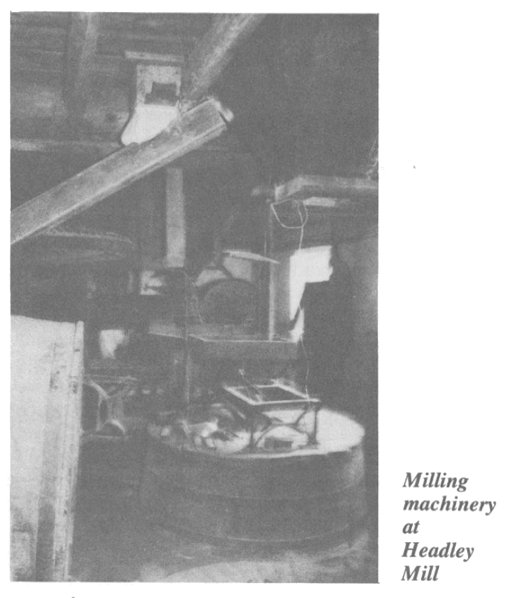
Remarkably the history of this mill has been traced back to the early 13th century. The names of the copyhold tenants are known from 1240 and those of the freehold landowners from AD 978.
The present buildings date from several periods, the oldest part being in the centre. The south-west end is considered to be 16th century. Major alterations took place in the 1790s. The mill had a wooden water wheel which was replaced in 1926 by the iron wheel which drives the mill machinery today.
A historical view of the mill is given in "Headley's Past in Pictures"
Standford Mill
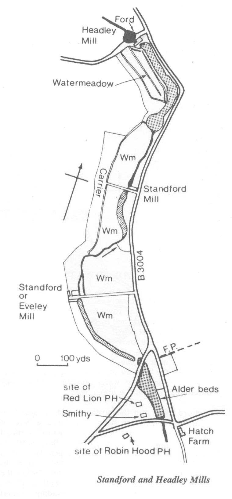
At Standford the area between the ford and the main road bridge used to be a mill pond serving Standford Mill on the outer side of the road.
Standford Mill (also known as Eveley Mill) was established as a papermill from around 1808 and closed in 1886. It was run in conjunction with Bramshott (Passfield) Paper Mill by the Warren family. Following its closure it was used to generate electricity for a laundry and for electric light. The mill has been demolished and a private house built on the foundations. Throughout the Middle Ages Standford had two fulling mills, one of which may have been on this site.
Standford (Lower) Corn Mill
Now a private residence this mill was working from the 18th century to 1929. Presumably like Eveley it was formerly a fulling mill. It had a 10ft undershot wheel.
(see the 'Mills' page for details of the mill wheel types)
A historical view of this part of the river is given in "Headley's Past in Pictures"
The Hollywater (known as the Deadwater in its lower reaches) has largely escaped cultivation owing to its inclusion in the royal forest of Woolmer, and later within areas owned by the Ministry of Defence and the National Trust. Only the reaches above Griggs Green are known to have been cultivated as watermeadows — the Hookes were “flowing” meadows near Foley Hatch in 1656, and their successors the Whiteheads were doing so in 1718 and 1738. Certainly the water quality is not much different to that of the upper Wey.
Conford Moor, on the north bank downstream of Conford village, has been designated a Site of Special Scientific Interest (SSSI) for its rich wetland flora. The base-rich fen of the valley floor contrasts with the acid bog and heath of the slopes. The soil in the higher slopes is acid and covered with birch, purple moor grass, bracken and heather. Below the spring line near the river there are wetland plants typical of base-rich conditions including several species of orchid.
Hollywater Pond
Fed by the River Hollywater, a tributary of the Wey, this pond is mentioned in 1350 as “la Holewatre juxta Iveleybrigge”. Its purpose is not known but it was probably created as a source of fish for the table. Until recently all that was left of the pond was a boggy depression overgrown with alder, and the remains of the dam and sluice. An inlet leat could be vaguely discerned at the top end.
The dam, leat and sluices were reinstated by the National Trust in 1986-7 with the help of the River Wey Trust.
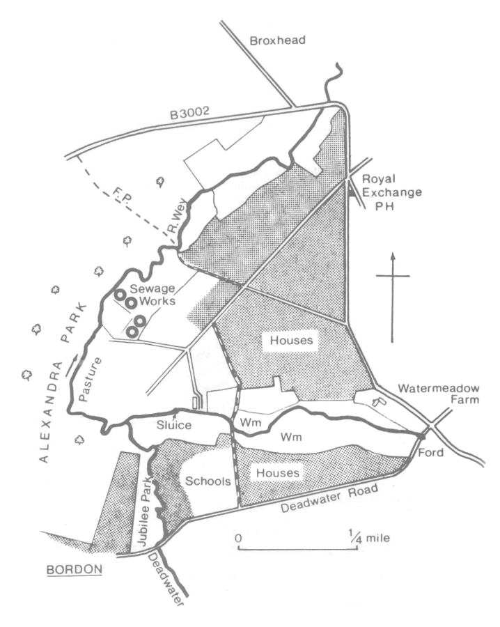
Downstream of the Wey-Deadwater confluence, the left bank (Alexandra Park) was for many years part of the army lands and appears not to have been cultivated.
There has been considerable development on the right bank, with the spread of Bordon and Lindford and the construction of a sewage treatment works. Nonetheless it is probable that this stretch contained watermeadows and would repay further investigation.
Passfield Farm
A well preserved example of a timber-framed house dating from the early 16th century. In 1846 the meadows to the north of what is now Waterside Lake were part of Passfield Farm.
Passfield Sluice
Looking downstream from Passfield Road bridge a bridge-like structure can be seen spanning the. river. Restored by the RWT in 1985 it is in fact a sluice used to feed the meadows on either bank by damming the river. It also served a secondary function as a bridge to enable the hay carts to get into the meadows. Road traffic used to cross the river at a ford where the current bridge stands.
Remnants of the watermeadows abound on both banks. On the left bank in particular the system of carriers and drains is visible, often only a few feet apart, spanned by cart bridges made from flat stones two or three feet square. The water table here is high and there are numerous springs and flushes, making for very difficult farming conditions. Certainly the meadows have been disused since the late 19th century and unlike other meadows no attempt has been made to graze them since the demise of controlled watering.
The high water table and lack of recent disturbance has produced a typical fen vegetation dominated by tall grasses such as Reed Canary Grass (Phalaris arundinacea) and Reed Sweet Grass (Glyceria Maxima) and sedges such as the Greater Tussock Sedge (Carex paniculata) and Lesser Pond Sedge (Carex acutiformis)\ It is a very rich environment for plants and insects as, well as sheltering deer and foxes. Alder and willow scrub is slowly invading.
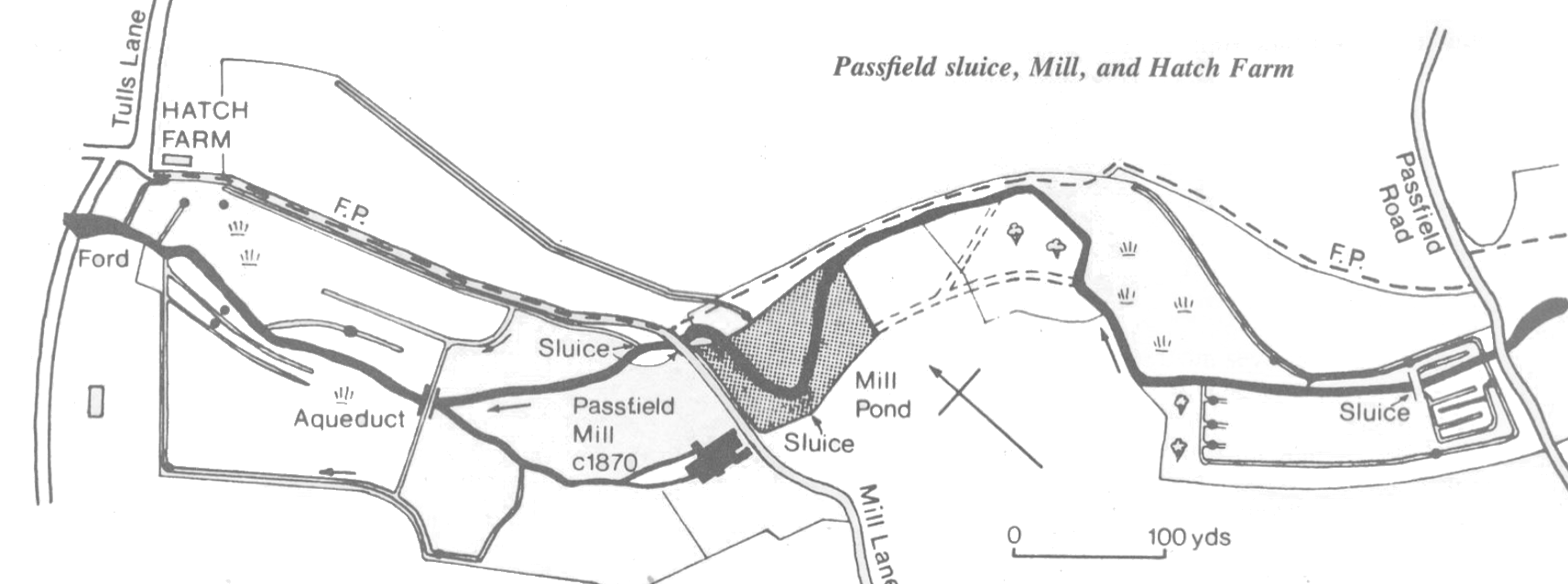
Passfield Mill
The mill buildings are currently home to light industrial works.
There was originally a corn mill on the site. Later, in the 1580s the Hooke family from Bramshott Place established an iron forge from which cannon balls have been found. It became a paper mill in 1684.
The Warren family were papermakers here from the mid 1820s. A.billhead from the 1880s advertised “paper and bags of all kinds made for every trade to order” including coloured papers, envelopes, account books, cards and note papers. They also had a printing press. From 1907 the mill produced postal order paper, and later the first Old Age Pension forms. Papermaking ceased in 1924 since when various light industries have occupied the site.
The mill pond is now filled in; the “original” mill buildings are comparatively modern, dating from 1856 to 1876 — other buildings are much newer.
Hatch Farm
Home of the Warren family and a working farm. The meadows on both sides of the river downstream •of the mill were water meadows up until the 1920s. John Warren, the present farmer, recalls the water meadows and aqueduct in use. He also remembers the constant supervision required, watering often continuing through the night, when there was no competition with the mill. The riverside meadows were fed from the river, via a sluice, but a second carrier led off from the mill pond to feed the meadow on the other side of the track. Today the meadows are grazed by cattle but many of the stops, hatches and cartbridges remain.
One of the meadows is an exceptional example of “unimproved” grassland. No artificial fertilizer has been used and the meadow now supports a flora of over 50 species including yellow rattle and southern marsh orchid, two species not found elsewhere in the valley. It is a good example of the diversity to be found in old meadows. The wet parts are covered with sedges, meadowsweet and rushes, whereas the drier parts have buttercups, ox-eye daisies and thistles. Such traditionally managed and species rich grassland is becoming increasingly rare throughout Britain.
The watermeadows at Hatch Farm incorporated an aqueduct to take water across the river to feed the meadows whose water supply had been cut off by the mill. It was very similar in design to the Radford aqueduct. John Warren remembers a local handiman, Mr Cannons, repairing the aqueduct around 1931-2. Today all that remain are the abutments, the span having collapsed into the river. Like many of these structures the process of decay has been hastened by the roots of ash and hawthorn. The RWT has carried out clearance and consolidation work.
The 17th century farmhouse here was replaced in 1921 by a large modern house in Jacobean style using in part (it is said) materials brought from a castle in Northumberland.
Just upstream from Passfield Road bridge the river is dammed to form a large lake. The lake was made early in the 20th century and was originally larger. Dam bursts between 1912 and 1914 and in the late 1920s caused flooding downstream as far as Headley Mill. The damage is said to have been so severe as to wreck Passfield Sluice, put many mills out of action, and covered a watermeadow at Headley Mill with dead fish. Prohibitive repair costs meant that many watermeadows were probably abandoned around this time. The remains of the original dam abutments still survive.
There were watermeadows on both banks throughout this length. The left bank watermeadows opposite Waterside house were planted earlier this century as a Japanese water garden, making use of the natural springs. The line of the main carrier continues from Bramshott Court. Water from the Bramshott Court system flows under the bridleway before returning to the river via a channel with stops. Ridges can still be made out amongst the trees and planted ornamentals. There is extensive bamboo and rhododendron scrub.
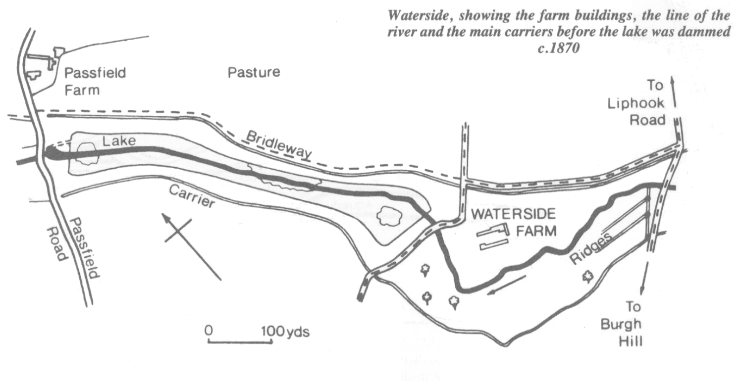
The right bank main carrier runs along the bridleway and is quite distinct downstream to the house. Beyond this the fields on either side of the lake have been heavily disrupted in recent times, burying the remains of the carriers and stonework.
In addition to being an attractive feature of the landscape the lake is home to a variety of wildlife. The islands are a refuge for birds including swans which nest in the willow carr.
Firgrove farm occupied the land now belonging to Bramshott Court and Bramshott Dene. The farmhouse stood on the site of the group of buildings known as Bramshott Court. (The tithe map shows Bramshott Meadows as part of Bramshott Farm).
Photographs from around 1910 show clear and managed watermeadows, with no trees. Today the right bank is almost completely wooded, whilst the left bank is garden and pasture. A sluice (restored by the RWT) towards the upstream end of the river feeds a carrier on the right bank. Further downstream an aqueduct takes this water over to the left bank to feed the meadow.
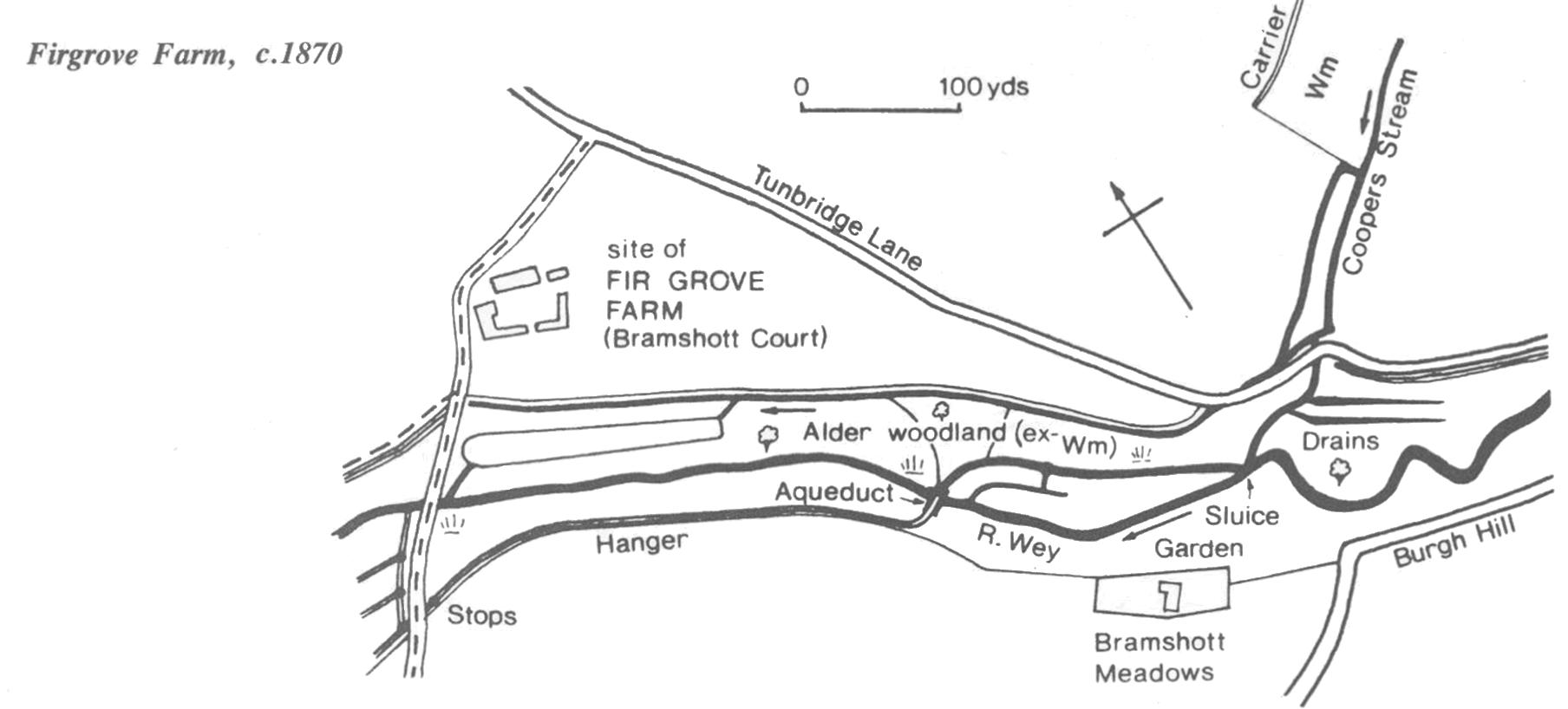
This century a succession of changes has been superimposed on the underlying pattern of the watermeadows. In the early 1900s some of the meadows were planted as water gardens after the fashion of the period. The watermeadow channels were incorporated into the design and enhanced with stonework to create cascades and ponds. It would appear that the upkeep required was too much, for the gardens were later allowed to revert in part to woodland. The gardens have been replaced with secondary alder woodland with a ground flora typical of other abandoned watermeadows, but interspersed with ornamentals such as Japanese maple, Persian ironwood, and bamboo.
The aqueduct (now known as Bramshott Court aqueduct) appears to have been positioned to exploit the additional source of water from Coopers Stream (the Waggoners Wells tributary) in order to provide a good flow in the carrier on the southern side, which would have been interrupted or at least depleted by the physical obstacles of the mill, a spur of hillside, and the road (Burgh Hill). Hatches allowed the tributary to discharge directly into the river when not flooding the meadows. The aqueduct is a Scheduled Ancient Monument and was fully restored by the River Wey Trust in 1986. Where the original stone was missing brick has been used, in keeping with current conservation practice.
The bridleway between Bramshott Court and Waterside is part of an old pack horse route which came down from Ludshott Common and crossed the river by Waterside, continuing southwards through Conford towards Weavers Down.
The Waggoners Wells tributary (known as Cooper’s Stream in its lower reaches) arises from springs near Grayshott and joins the Wey at Coopers Bridge/Bramshott Meadows.
The stream has been dammed to form a series of ponds at various times. The best known are the three ponds below the ford and the National Trust car park. Two of the ponds were made or enlarged c. 1623 by John Hooke, then Lord of the manor. He diverted the stream and flooded manorial waste (not what we might call waste but valuable heathland grazing), which raised complaints from neighbours and tenants. The purpose of the ponds is unknown. They are often described as Hammer ponds, (e.g. Canon Capes, “Rural Life in Hampshire”, 1901) but there is no real evidence to support this explanation. They may have been created to stock fish or to act as a reserve water supply for the watermeadows and mill at Passfield — very possibly for both reasons.
Today the ponds are stocked with fish. The upper pond holds mainly roach and perch, the middle pond is currently stocked with trout, whilst the lower is known for the very large carp which can be seen basking at the surface in warm weather. It is a good place to see kingfishers.
The surrounding woodlands are predominantly beech, with alder in the valley bottom. On the higher slopes birch grades to heath and bracken. Bilberry (Vaccinum myrtilus) grows along the pond banks.
Waggoners Wells and the surrounding commons lost many trees in the storm of October 1987.
Further downstream the stream flows through Downlands Estate and Coopers Bridge before joining the Wey at Bramshott Court. There are watermeadow remains throughout the length of the stream.
Bramshott Vale
Originally built as a farm by John Butler in 1732 and known as Shorts — later as Bramshott Farm. There were watermeadows here in 1690 on the fields between the carrier and the river. When the land was sold in 1910 the new owners had to sign a covenant promising to keep their watercourse “in proper order and condition”.
Sydney Moss describes cutting grass and haymaking here in the 1920s (“Liphook Remembers”): “After cutting the grass (with scythes in my younger days) it had to be turned with wooden rakes, then came cocking with prongs, pitching up on to waggons and pitching up on to the rick from the waggon ...”
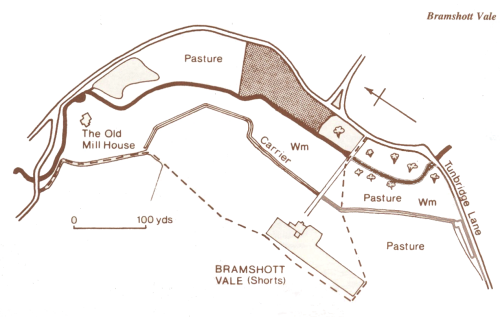
The meadows today are improved grassland used for pasturing sheep and cattle. Highland cattle were introduced in 1986. The river flows through a narrow belt of alder woodland. Upstream of the drive it is open to the grazing animals while downstream the woodland is fenced off. It is interesting to note the effects of grazing on the ground flora, suppressing the woody shrubs such as bramble. The large oak near the gate was one of a pair. Its twin was felled in early 1988.
Bramshott Corn Mill
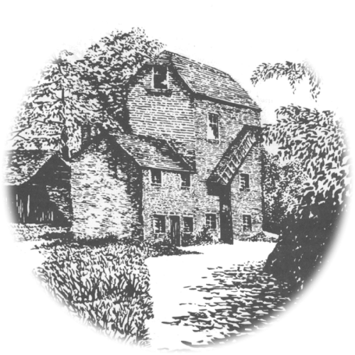
Also once known as Bramshott Old Mill and now known as “The Old Mill House”, this mill was built in 1750 and was grinding corn into flour up until 1912. The site had probably been used for this purpose since Domesday. Although the millhouse was burnt down in 1913 the mill itself survives as a private dwelling, converted in the 1930s and substantially remodelled. The illustration is from a turn of the century photograph. The present pond is a recent re-excavation fed by springs. The sluices remain in fine condition.
In 1932 the son of the last miller (c. 1900-12) recalled that . . the Chalcrafts, who had the land above the mill, got three crops of hay off their meadows”. His father had grumbled that they starved the mill of water in order to do so.
Before 1895, when the bridge was built, the road crossed the river slightly upstream at a ford known as Longford.
The aqueduct, a Scheduled Ancient Monument, was an important feature of the watermeadow system mentioned in the 1690 agreement. It continued to function into this century, bringing water from the right bank, over the river to water the meadow on the left bank. The carrier on the left bank seems to have been blocked when the Portsmouth road (A3) was raised (the road was turnpiked for coach traffic c. 1750) but there was already an “arch” according to the 1690 agreement. By the 1970s the Aqueduct was badly cracked and in imminent danger of collapse. Restoration by the Bramshott and Liphook Preservation Society, (grant aided by HCC, EHDC, and DoE) sparked local interest and led to the formation of the River Wey Trust.
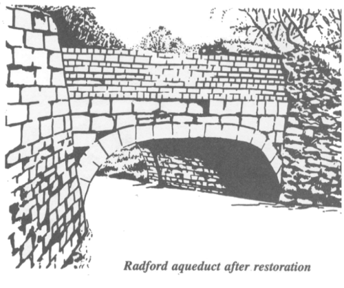
From the aqueduct the carrier continued on the left bank downstream, supplying water to Radford and Tunbridge Meadows. Radford Meadow was most recently the site of an abattoir, the foundations of which remain, disrupting the carrier for some distance. Nevertheless there are excellent ridge and furrow remains and a good wetland flora including the Common sedge (Carex nigra). Willow scrub is encroaching.
it is here that the Liphook by-pass was built, opened in July 1992. .
Tunbridge Meadow
Continuing from Radford Meadow the main carrier runs along the top of Tunbridge meadow where there are two stops which have been cleared by the RWT. These are more substantial than is usual in this position and in very good condition, possibly due to the dry conditions. There is ridge and furrow on the flat part of the meadow.
After leaving the meadow the carrier crossed Tunbridge Lane, passed through a roadside pond (which the RWT plans to restore) before continuing to Shorts (Bramshott Vale).
Previously known as Ratford and before that Calvecroft or Cacross.
Situated in Liphook itself, Radford Park is well known to Liphook residents, being readily accessible and well publicised. The park was created for a broad range of recreational uses and a balance has been struck between the more formally landscaped areas and “natural” meadow and woodland.
Much of the southern meadow adjacent to the A3 has been obliterated by tipping, particularly during the construction of the dual carriageway. The tipped area was levelled to create the raised grass area which has been planted with ornamental trees. A group of large stones left from the roadworks stands like a 20th century stone circle. The river has been diverted from its old course to the north and now runs much closer to the line of the right hand carrier. In so doing, the carriers and drains below the pond have been truncated.
There were two sluices on this stretch of river — one at the upstream boundary of the park feeds the right hand carrier while further downstream are the remains of the sluice which served the left bank carrier. The outline of this carrier can be seen along much of the southern boundary of the park and drains persist in the boggy ground, overgrown with wood club-rush.
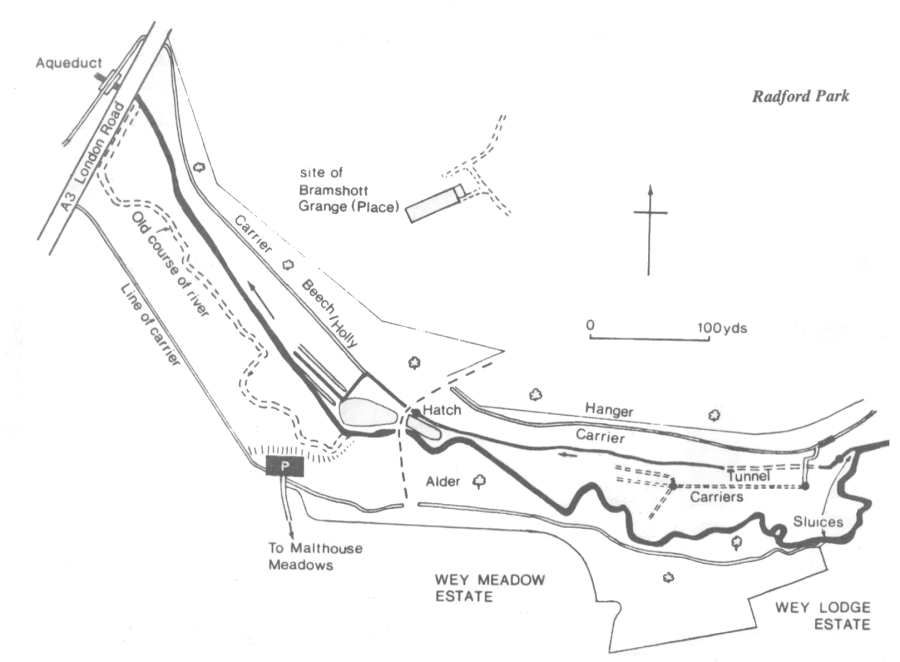
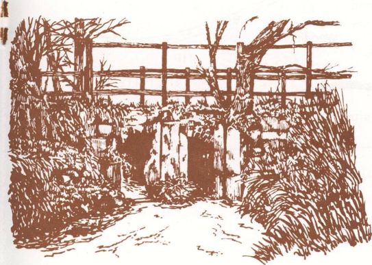
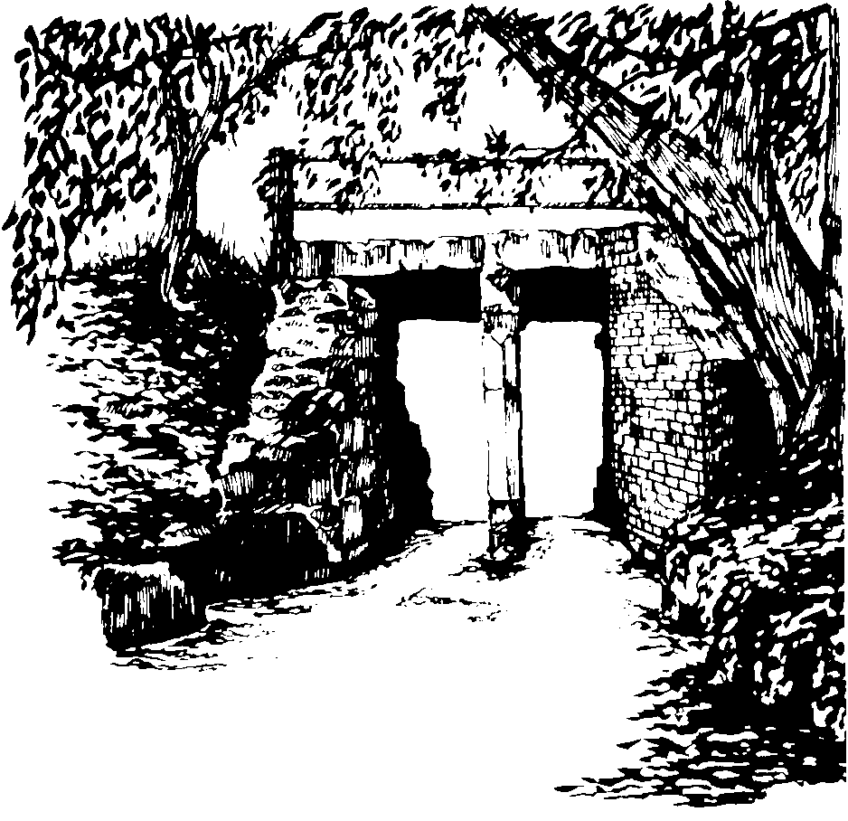
Shortly after it leaves the river, the right hand carrier rather enigmatically disappears into a tunnel, re-emerging 100 metres further on. The tunnel roof is lined with stone and obviously involved considerable expense and effort. The reason and date of its construction is unknown — access to the meadow is made easier but this could have been achieved simply by construction of cartbridges as elsewhere. The mystery may remain unsolved. The carrier now runs permanently, carrying water to the ponds. The outline continues under the hanger for the length of the park. Originally the carrier continued under the road to feed the downstream meadows, crossing Radford aqueduct to supply the left bank. Higher up runs the carrier once fed by the sluice at Lakehouse.
The area now covered by Radford Park includes two meadows formerly belonging to Malthouse Farm (now a housing estate) and the land formerly known as Calvecroft, Cacross or Ratford. In 1618 Richard Wyatt, a London merchant left in his will “all my lands at Bramshott” (including Calvecroft or Cacross) to the Carpenters Company.
Bramshott Grange
On the northern side of the valley above Radford Park, Bramshott Grange was built c. 1857 on the site of Bramshott Place, a Tudor mansion and the home of the Hookes from the late 1500s. A gatehouse is all that remains of Elizabethan Bramshott Place.
There are some notable specimen trees in the grounds planted at about the time the Grange was built.
Downstream of Lakehouse, a bridleway crosses the valley. The meadows between this bridleway and Radford Park belong to Marshes Hollow, the house on the bridleway. There are two meadows on the left bank and three on the right.
Prior to the building of Wey Lodge estate most of the left bank was part of Collyers Farm. Of the two remaining riverside meadows the upstream one was part of Lakehouse Farm and the lower belonged to Collyers. The upper meadow on the right bank was “Marshes” while the downstream two belonged to Bramshott Place (the Hospital).
There is good evidence of watermeadows on the right bank — a carrier is visible over most of the length and various other watercourses are apparent. All three meadows are very different today. The uppermost is open, wet, and has two deep drains running across the centre. These were probably watermeadow drains deepened in more recent times. The meadow is full of rushes and covered with cuckoo flower (Cardamine pratensis) in spring.
Immediately downstream is another much drier and partly wooded meadow. Carriers are clear and oak and alder grow here. The oaks are small and exhibit a clear “browse line”, the result of recent grazing by sheep.
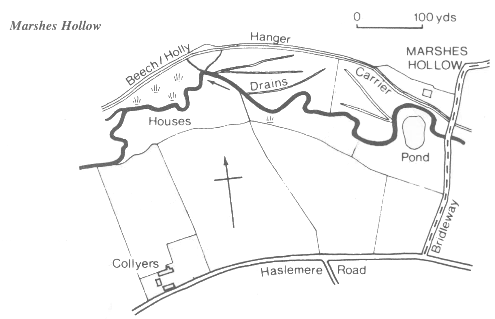
Further downstream the ground is very wet. Wood club-rush (Scirpus sylvaticus) and balsam grow waist high. This meadow must have presented the meadsmen with great problems.
On the left bank there are two meadows. One is now garden with a pond and a row of poplars. Beyond that is grassland.
The farm buildings were situated just west of the railway bridge on the Haslemere Road, Liphook. The house was demolished in 1969 for road widening but several meadows remain. The farm appears to have held all the land on the left bank downstream from what is now the trout farm to the bridleway at Marshes Hollow. The 1846 tithe map also shows the first meadow downstream of the bridleway, now part of Marshes Hollow, as part of Lakehouse. The total area of the farm was given as 43 acres, of which only 2 were watermeadow, although in 1690 the farm had included 5 acres of watermeadow.
There were two watermeadows immediately below the farmhouse, between the sluice and the bridleway at Marshes Hollow. The sluice has been restored by the RWT. Two parallel carriers can be made out at the foot of the slope behind the farmhouse. The meadows upstream were originally watered but would have fallen into disuse in 1859 when the railway was built. They were subsequently used for grazing cattle. There are land drains (put in by Frank Moss, the farmer, earlier this century) but no sign of the old watercourses.
The vegetation of these grazed meadows is rather unusual within the context of the Wey. Tormentil is common and marsh pennywort grows on the river bank. Both are rare elsewhere, preferring a more acid soil than is usual near the river. Their presence may reflect the quality of the water running off Linchmere.
Harold Budd (born in 1911), a long time resident of Lakehouse, recalls his father talking of the watermeadows: “The men would flood the meadows for 2 or 3 days in the spring . . . the early crop was scythed and carried to the cows and calves in the shed on it . . .” Visiting the site for the first time in twenty years he pointed out the old and split crack willow that had grown from the pole he had put up for his mother’s clothes line. Each farmworker was allocated a length of riverbank from which he could cut the alders in rotation for firewood.
In 1987 during renovation of the sluice the RWT found three rusting metal grids in the river. These were put there by Colonel Hill who stocked the river with trout. The grids were supposed to keep the colonel’s fish from straying.
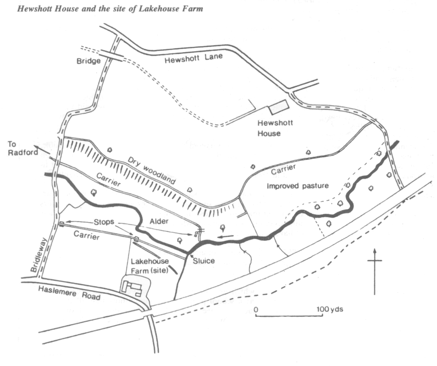
A stop on the carrier can be seen beside the bridleway.
Hewshott House
On the other side of the river the meadows have become overgrown with woodland. This land belongs to Hewshott House, previously Hewshott Hill House. Water was turned into these meadows by the Lakehouse sluice. Carriers and drains are apparent amongst the woodland. The carrier which runs high along the hanger was fed from the sluice near the Prince of Wales pub.
Most of the right bank upstream as far as Hammer belonged to Hewshott Hill House at the time of the 1846 tithe map.
Around this area are an example of a complex watermeadow, with channels crossing over each other to achieve the irrigation required.
Sluice restored by RWT
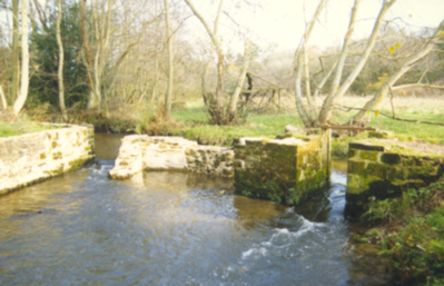
Upstream of the path which crosses the river near the Prince of Wales pub is a small overgrown meadow. A sluice here, now ruined, fed a carrier on the right hand bank. Downstream on a sharp bend in the river another sluice used to feed the carrier on the left bank. Already much repaired, this is in an advanced state of decay. Originally the upper sluice would probably have served both banks, but construction of the railway in 1857 buried much of the left carrier and necessitated a second sluice. Although this land is woodland today it was all open just before the war. The remains of drains and carriers are everywhere.
There are interesting local variations in the vegetation: alder in the valley bottom; willow, wood club rush, and balsam in the depressions; and birch and oak on the hummocks. Above the carriers the vegetation changes distinctly. Oak birch and holly predominate whilst Sphagnum moss thrives in the wet hollows, reflecting the more acid conditions away from the influence of the river water. Wood horsetail is found at the downstream end where the ground is particularly wet due to the trout farm sluice immediately below.
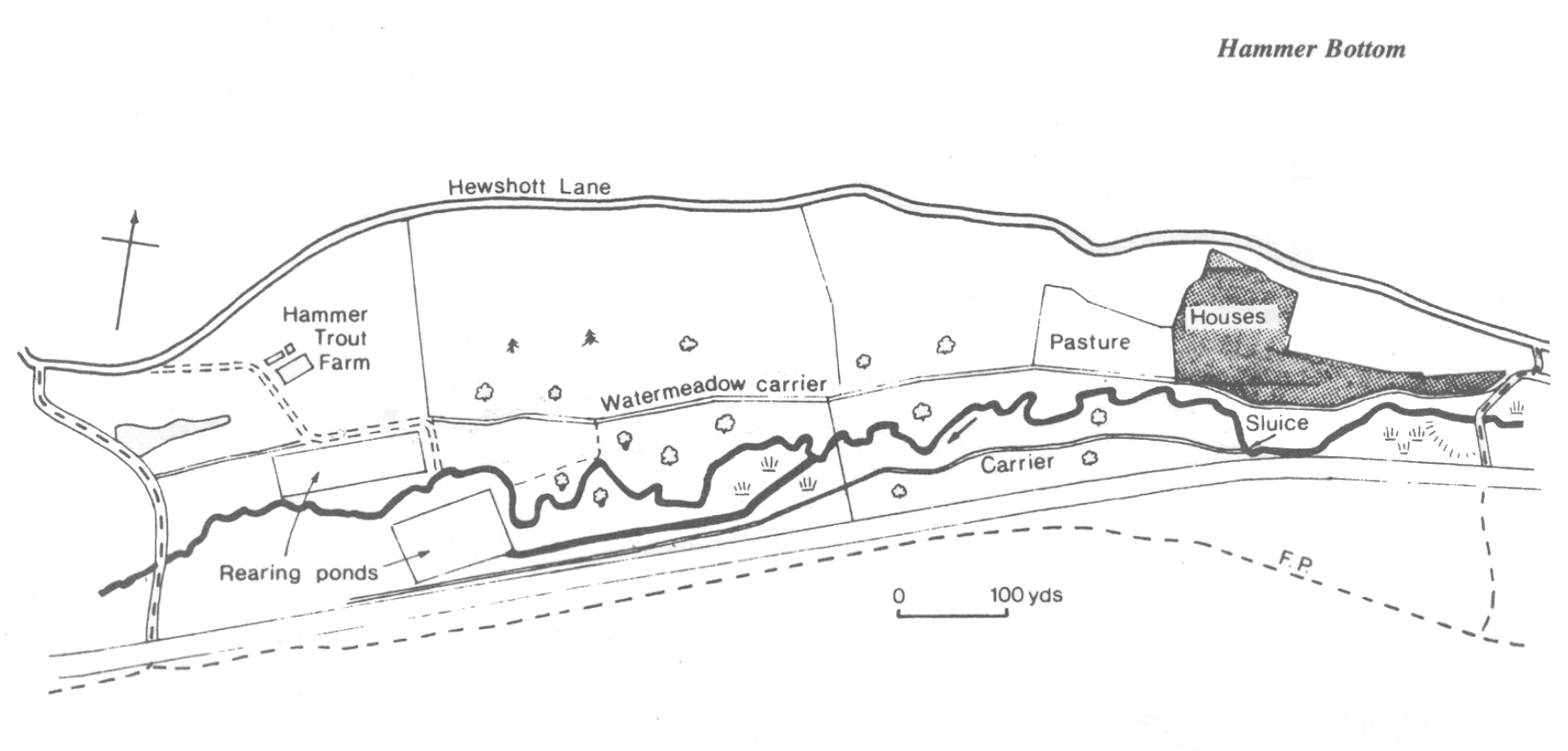
A working trout farm built on abandoned watermeadows. The indoor hatchery is fed by springs which provide the stable flow and temperature requird for low mortality. When the fish reach a certain size they are transferred to rearing ponds, fed by a modern sluice and carrier from the river. Rainbow trout are reared for the table.
The main watermeadow carriers are visible on both banks. Several stone stops remain. The meadows were a continuation of the Hammer Bottom meadows above.
There is a pond at the downstream end by the bridleway. The bridleway is an old cart track that may have been built to serve the iron industry. The right hand carrier crosses this track to run at a high level, just below Hewshott House.
From Pophole downstream to Bramshott the river valley is a mixture of woodland and pasture with some land incorporated into gardens. Previously this length was managed virtually exclusivly as watermeadow from the 17th untilthe early 20th centruy.
Below Pophole the two branches of the river pass under the road. On the far side the enclose a small meadow before rejoining to pass under the railway. This meadow may well have been watermeadow but has been filled, obscuring any original structure.
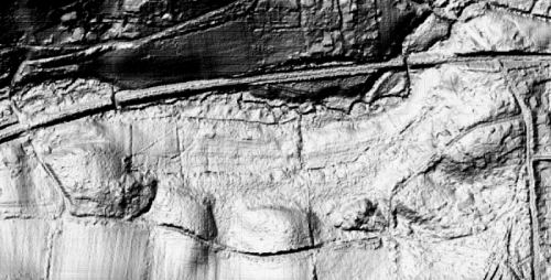
From the railway bridge downstream there are extensive watermeadow remains. A carrier is visible along the southern edge of this meadow, albeit now only spring fed, but originally perhaps fed from the pond at Pophole, and there are traces of ridge and furrow.
A second carrier follows the line of the hedge near to and parallel to the river, returning to the river via a hatch.
The LIDAR image and diagram below show these features.
This meadow is occasionally lightly grazed by horses and has not suffered the overgrazing so often seen in horse paddocks. There is an excellent meadow flora of more than fifty species including heath spotted orchid.
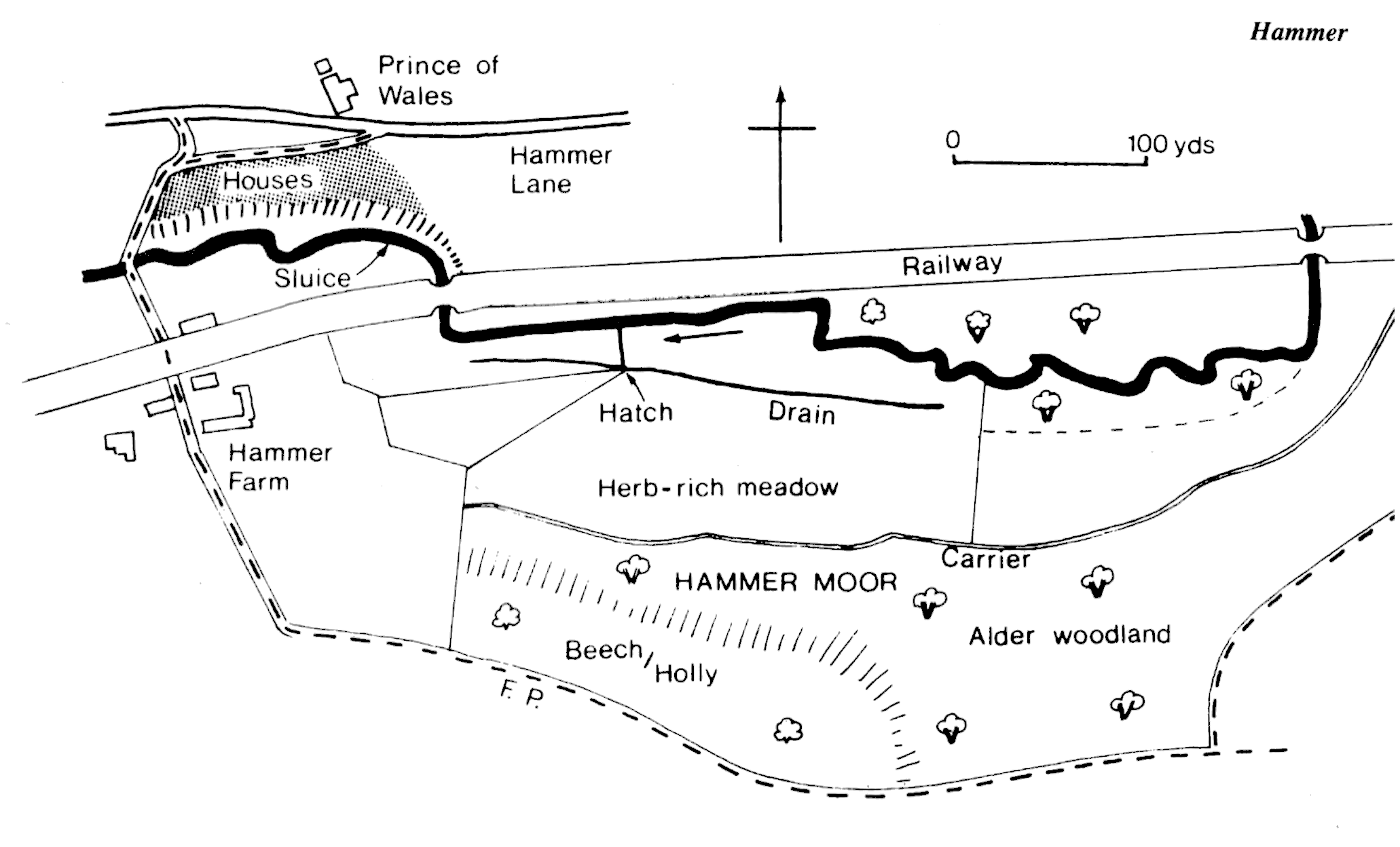
Pophole marks the start of the River Wey Conservation Area — designated by East Hampshire District Council but including a strip of West Sussex on the south bank between Hammer and Liphook.
The site of one of the oldest mills on the river, Pophole straddled the boundaries of three counties. It is mentioned in a perambulation of the bounds of Woolmer and Alice Holt forests in the reign of King John c.1200. By 1573 the site was part of the flourishing Wealden iron industry, with a forge and furnace, water-driven hammer and bellows. The mill had fallen into disuse by 1777.
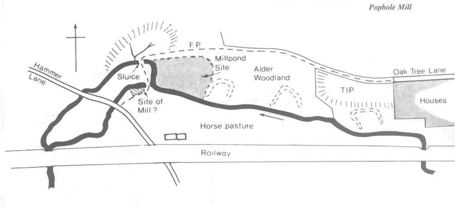
Today only the sluices and leat remain: limited restoration has been carried out by the RWT. Heaps of slag can be found downstream in the undergrowth. The sluices serve as one of the footbridges. Slotted stones on the upstream side are a clue to the one-time existence of a millpond. The river emerges as two branches below the dam. The workings were probably on the Sussex bank immediately below a second, more recent footbridge. The bank has been filled and raised on the south side of the river, and apart from some masonry adjacent to the river, any mill foundations have been obscured.
The mill pond has silted up and reverted to wet alder woodland which is home to a wide variety of wetland plants including the wood horsetail (Equisetum sylvaticum) and the moss Hookeria lucens. The river has been straightened and the banks are open but its original course can be traced from waterlogged “ox-bow” hollows in the woodland.
No mill buildings remain, indeed it is quite possible that the site was an open working. Two nearby cottages could well have been associated with the mill. One is timber-framed, the other, perhaps more recent, may have been an outbuilding.
A second stream feeds the Wey from the south side of Gibbett Hill, flowing south into Haslemere where much of its course is obscured. In the last century there were watermeadows upstream of Sickle Mill.
Lane End Farm
At what is now Junction Place. There were watermeadows including Perpresture meadow immediately above Sickle Mill pond, and Lion Mead immediately upstream of that. Both are mentioned in the diaries of James Simmons III in the late 1830s. They were cut for hay twice a year — in late June/early July and again in early September. These meadows have long since been built on.
There were four water mills in the Shottermill/Camelsdale area to the west of Haslemere. The proximity of so many mills in such a small area illustrates how much power can be obtained from a small river if there is sufficient fall.
All four mills belonged at one time to the Simmons family. Shottermill was a corn mill, while Sickle, Pitfold and New Mills were all papermills.
Sickle Mill
This appears at one time to have been an iron forge. It was taken over by James Simmons in the 1730s. Paper making was first mentioned in 1736. It was probably converted to machine papermaking in the 1830s. Sale particulars of 1854 describe the mill as water with auxiliary steam power. There were two overshot waterwheels 16 and 17 feet in diameter and a rag boiling house. There were also detached rag sorting and drying houses by the pond.
James Simmons’ III diary for 2nd June 1838: “Fished Sickle Mills pond, drew it low last night. A great quantity of gudgeon, one pike nearly 5 pounds, a few good trout and also perch. The carp good. Put back 10 or 12, the largest weighed 7 pounds.” On the 4th June he was “Busy sending out the fish”, so presumably they were sold for eating. At other times fish were transferred between millponds thus making maximum use of an incidental resource.
In 1860 the mill was taken over by Henry and Thomas Appleton, who continued making paper until 1870 when Sickle Mill went over to making braid and epaullettes in line with the Appleton’s other mill at Elstead. The mill was sold to the local authority in the 1920s and is currently used as a storage depot by Waverley Borough Council. The mill pond has been filled in and the stream has been piped underground.
Shottermill
A short distance downstream from Sicklemill, after the confluence with the Blackdown stream, and below Camelsdale Recreation Ground is the sluice which was used to divert water along the mill leat to power Shottermill.
The leat was re-excavated by the RWT in 1986 but water now flows in the reverse direction, coming from the mill ponds rather than the river which now by-passes the sluice. There are two overflows on the leat, one close to the sluice, and another further downstream behind the new houses. The mill is situated on the main road opposite the Mill Tavern (formerly the Railway Tavern). The leat flows under the B2131 road to rejoin the river on the opposite side, a short way downstream.
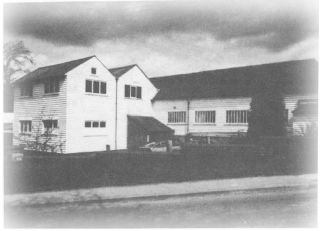
The mill building is now residential but remains essentially intact. Windows have been added and the wooden lean-to which enclosed the overshot wheel has now gone. The ponds were created to provide an extra head of water when more power was needed.
The river banks and the slope above the leat support a rich flora — a mixture of alder, unimproved wet grassland and scrub — sallow in the valley bottom, mainly birch above the leat. The soil here is underlain by Atherfield clay which is responsible for the bright orange colour of the mud exposed where there are springs. This is also an important stopover point for migrating birds.
Pitfold Mill
Pitfold Mill was located on the tributary stream which flows southwards from Woolmer Hill and th^ Nutcombe Valley. Until early 1988 parts of the foundations could be seen, as well as the springs which supplied the washing water. In February 1988 work began on a housing development on the site.
The mill was owned by the Simmons family. It was first referred to in 1801 when it was insured together with Sickle and New Mill. It was described as brick, timber, and tiled. When it was insured a year later the paper-maker was John Howard. Sale particulars in 1832 refer to a 17ft waterwheel, engine gear, running tackle, vats and chests complete. It was closed as a paper mill in 1870 and used for dressing leather. Later a saw mill was erected on the site.
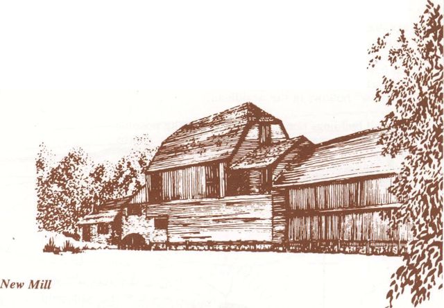
New Mill
New Mill was opposite what is now the sewage treatment works. Following the footpath over the stile and bridge the mill pond was on the left. The footpath follows the line of the dam and the mill was on the right. No visible traces remain, except for the sluices, the mill pond having been filled in and the mill demolished in 1976.
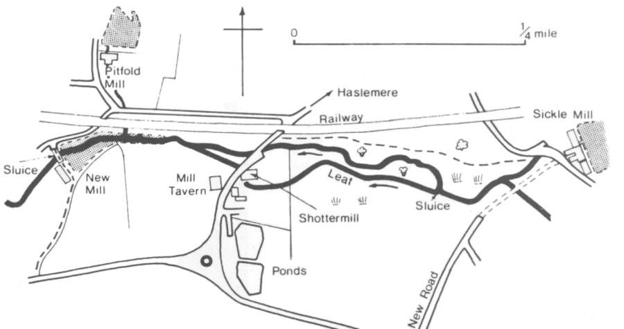
A brick building with an inside, breast-shot wheel. New Mill was making paper by hand around 1800. Sale particulars c. 1832 refer to it as Hall’s Mill, “a compact, substantial mill, fall being upwards of 5ft .. . an increased power being obtained by sinking the water course below the mill. Pond of 1.5 •acres.” From 1839 onwards the paper making process became mechanized.
The Ordnance Survey map of 1873 describes it as a flour mill. In conjunction with Pitfold Mill leather was produced for a period up to 1882 when it was last referred to as a working mill. Inspection in the late 1940s showed the beams to be studded with nails over which skins had been stretched.?
By 1918 a rabbitry was established here and later on a small carpenters shop occupied some of the premises. In the 1930s the mill served as a pig farm, all the machinery having been removed and the pond having reverted to “swamp”.
The mill cottages which stood on the other side of the river were demolished in early 1986.
The sluices are extant and in good condition having been extended to make the footbridge over the river. The large stones grooved to accept sluice boards are located on the upstream abutments.
The toothwort Lathraea clandestina grows on tree roots along the river bank, probably a garden escape. The depression immediately below the footpath is rich in wetland plants, including the pendulous sedge (Carex pendula). Wood horsetail grows further up the bank under the trees. Several fruit trees (apple, pear and plum) by the river are probably a legacy of the mill. James Simmons' diaries refer to an orchard planted in 1835. In his time the wooded slope which is now the site of the spring-fed ponds was watermeadow and belonged to the mill. The millpond was also managed as a fishery and periodically fish were removed, presumably for the table.
On the south side of the millpond amongst the trees are a series of rectangular depressions. These were the rearing ponds of the Surrey Trout Farm. The ponds further up the hill were also part of the operation, the springs supplying a reliable source of clean, well oxygenated water, relatively cool in summer and warm in winter. The trout farm was founded by a Mr. Andrews of Guildford in the late 19th Century and thrived up until the 1960s.
“It is interesting to remember that the eggs from which sprang the stock of trout in the rivers of New Zealand were originally sent out from Surrey by Mr. Andrews and that the rivers of Kashmir were first stocked by the Surrey Trout Farm.” (The Homeland Handbooks Guide to Haslemere and Hindhead. 1911). The fish were probably native brown trout rather than the American rainbow trout more commonly reared in fish farms today. The company also provided the stock from which the British record carp came. Surrey Trout Farms had another trout farm above Pitfold Mill. This area has been built on but slotted stones for hatches have been found in at least one garden.
Immediately below New Mill the valley has been spoilt by tipping and a sewage treatment plant. The river has been straightened and the banks are high. In the last century this was arable land growing wheat. Today Coltsfoot and Rosebay Willowherb grow on the disturbed ground.
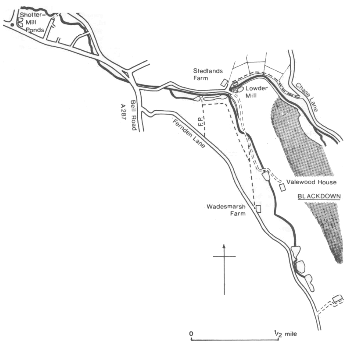
One of the main tributaries rises at Cotchet Farm, Black Down. It can be seen running beside the track which leads from Fernden Lane up to the farmhouse. Water from the surrounding hills gathers in the valley and drains into a series of ponds before following the valley down to Haslemere.
The stream flows through open pasture as far as Valewood Farm — woodland covers the higher slopes. A bridleway follows the eastern slope of the valley on the edge of the NT woodland and there are footpaths which cross the valley further down.
A second stream drains a parallel valley to the east. A footpath from Chase Lane to Stedlands Farm affords a reasonable view. A strip of alder woodland runs along the poorly drained valley bottom with pasture on the valley sides. The wood on the higher slopes is coppiced chestnut. Sweet chestnut (Castanea sativa) has long been coppiced — cut down and allowed to regrow every 15 or so years — for the production of timber for fencing. In the past chestnut was widely used for sheep hurdles and the traditional Sussex “trug”, a type of basket known to gardeners. Today these are more likely to be made of metal and plastic respectively.
In the valley bottom is a little brick building, half hidden in the trees. This pump house was part of a water supply system for Haslemere. The two streams come together by Stedlands Farm and, supplemented by springs, follow Bell Vale Lane. There are several spring-fed ponds here.
Downstream of the A287 road junction the river flows behind houses and becomes inaccessible. Further downstream where the road forks the river crosses under the road again. From here to Sickle Mill used to be Sturt Meadow, part of Sturt Farm and probably all watermeadow (the tithe maps do not often make the distinction between watermeadow and ordinary hay meadows). Today it is mostly housing. Below what is now Sturt House, the Black Down tributary joins the tributary from Gibbett Hill.
-32-


