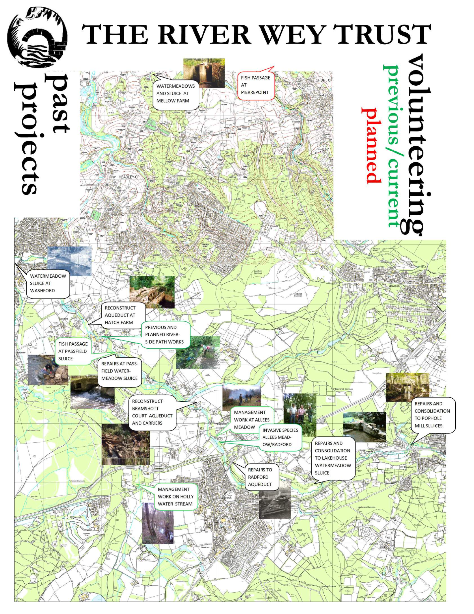
A summary of the Trust's Projects.
All our projects and activities benefit from help and assistance from friends and volunteers, and that programme is shown on the 'Volunteering' page.
|
|
|

All our projects and activities benefit from help and assistance from friends and volunteers, and that programme is shown on the 'Volunteering' page.
|
|
|
Sicklemill, Haslemere |
|
|---|---|
Status |
Within the Conservation Area Semi-redundant storage building, former mill (flocking). Large pond now filled and part developed as an industrial estate. |
Work to be undertaken |
Investigation of machinery etc. Partial restoration of pond. Interpretation - probably by Waverley BC |
Habitat |
Disturbed ground (fill) of little interest. A small area of water survives. |
Ownership/Access |
Owned by Waverley BC - A287 runs in front. |
Comment |
An impressive set of buildings. Waverley BC have a development brief which involves retention of key parts of building and removal of recent accretions. RWT has been offered space for display. |
Budget |
None at this stage |
Shottermill |
|
|---|---|
Status |
Within the Conservation Area Mill building survives, with long leat. Possible meadows. Mill buildings now builder's yard/shop/office. |
Work to be undertaken |
Excavation of leat inlet sluice, weir and first section of leat. Continue investigation/clearance of leat and possible meadows. Consolidation work to sluice and leat controls. Target: re-establish flow of water in leat. Interpretation. |
Habitat |
Meadows/leat not yet surveyed. Adjacent (National Trust) ponds are spring-fed are artificial; used by waterfowl. Wet woodlands regarded locally as important nesting site |
Ownership/Access |
B2131 crosses in front of mill; public footpath near leat sluice; RH bank belongs to Waverley B.C., left to Fernhurst/Linchmere PCs |
Comment |
An interesting site in context of a real river as a whole, Mill buildings largely converted to flats; Leat runs through area of recreation ground in public ownership and is amenable therefore to effective interpetation. |
Budget |
Budget costs: for restoration work by Trust: £500 |
New Mill and Pitfold Mill, Critchmere |
|
|---|---|
Status |
Both mills demolished and ponds filled in ; some controls survive. |
Work to be undertaken |
Investigation and consolidation; interpretation. |
Habitat |
Grassland, scrub and fen with flushes. Locally disturbed ground. Upstream of Pitfold - to be investigated. |
Ownership/Access |
New Mill : cul de sac and public footpath cross river valley, Pitfold Mill (tributary) visible from road. |
Comment |
Little obvious remains, other than good sluices; ecologically of local interest due to contrast. |
Budget |
Restoration work by Trust: £500 |
Pophole Mill, Hammer |
|
|---|---|
Status |
Within the Conservation Area Mill site (iron) late 16th century. Impressive sluices remain with dam, slag, and wheel-drive position. No Machinery or buildings survive - disused mid 18th century |
Work to be undertaken |
Repairs and consolidation of sluices and abutments, consolidation and stabilisation of dam at drive position. Interpretation; re-establishment of the area of the mill pond, check upstream for meadows. |
Habitat |
Wet woodland with flushes. Straightening the river has left small very wet areas of fen (oxbows). Flora includes Equisetum sylvaticum, Luzula pilosa. Adjacent steep hillside with heathland and Sphagnum spp. provides interesting contrast. |
Ownership/Access |
Several ownerships involved. Public footpath runs over dam; permissive access to whole area. Road crosses river valley downstream. |
Comment |
Key site - important remains and highly accessible |
Budget |
To Date : Stone for central pier in stock paid £300 paid by Waverley BC to Bramshott and Liphook Preservation Soc Budget for restoration work by RWT £4500 |
Hammer Bottom |
|
|---|---|
Status |
Within the Conservation Area Watermeadow: left sluice survives, right sluice completely collapsed, much of the central area reverting to wet woodland. Hammer Trout Hatchery at downstream end, some excellent stop survivals. |
Work to be undertaken |
Consolidation of left sluice, clearance of carriers and consolidation of stops |
Habitat |
Wet woodland; fen. Typical of meadow having reverted to alder woodland. Wettest areas (hollows) have become fen. The largest area of uninterrupted wet woodland in the valley. Flora predominantly Impatiens glandulifera, phalaris arundinacea, sallow, and scirpus sylvaticus. |
Ownership/Access |
several different ownerships; Public access limited to bridleways to downstream and near the upstream end. Road runs parallel with the river but little view of the river - some good views of the valley. Access by arrangement with owners; railway runs near the river on the left bank. |
Comment |
ecologically sensitive with some good minor remains; poort access may be ecologically beneficial. |
Budget |
Restoration work by RWT £750 Onsite interpretation £100. |
Lakehouse Sluice |
|
|---|---|
Status |
Within the Conservation Area Watermeadow sluices (Part collapsed), carriers controls and meadows ; possible mill-site, (+ carriage drive over downstream bridleway.) |
Work to be undertaken |
Clearance and consolidation of sluice, controls and carriers ; investigation of meadow layout. Archaeological investigation of possible mill-site. |
Habitat |
left bank: improved pasture (watermeadow) Flora: Juncus effusus, Rumex obtusifolius right bank: wet woodland, fen - as Hammer Bottom Flora predominatly Impatiens glanduliferao, phalaris arundinacea, sallow, and Scirpus sylvaticus |
Ownership/Access |
access by arrangement with landowners. One: absentee Bridleways cross River Valley to upstream (ancient track and bridge) and downstream. B2131 runs parallel with downstream portion. |
Comment |
possible site of local historic importance. |
Budget |
for restoration work by Trust: £1500 onsite interpretation: £100 |
Marshes Hollow |
|
|---|---|
Status |
Within the Conservation Area Meadows ; form well preserved due to grazing (until recently) by sheep. |
Work to be undertaken |
investigation of system and controls consolidation where appropriate. Bridleway overbridge at top of hill requires repair |
Habitat |
left bank: pasture/watermeadow, then urban right bank: grassland/fen reverting to wet woodland:process less developed than elsewhere (? due to sheep- grazing) Flora include Sparganium erectum, Scirpus sylvaticus |
Ownership/Access |
access by arrangement with owner only Bridleway crosses River Valley upstream. |
Comment |
good meadows : improved access unlikely |
Budget |
for restoration work by Trust: none at this stage onsite interpretation: £100 for bridleway bridge: £750 |
Radford Park |
|
|---|---|
Status |
Within the Conservation Area Watermeadows, carriers, controls, tunnel and sluices (including carrier feed to aqueduct ; downstream left + part of right) meadows tipped and filled, and river locally diverted by A3 dualling 1960s. Right carrier largely restored and made operational by Parish Council's MSC team. Run as 'Country Park' by Parish Council, providing circular route, restored ponds and tree planting, with car parking. |
Work to be undertaken |
Work to be undertaken : Further investigation of upstream watermeadows ; complete clearance of downstream right sluice ; repairs to tunnel ; repairs to hatch at head of right carrier ; restoration of right sluice. Interpretation (possibly by Bramshott P.C. |
Habitat |
Grassland (meadow); woodland, some wet; Landscaped recreational area, particularly on old tipped area. |
Ownership/Access |
Parish Council ownership - unrestricted access ; abuts A.3 downstream. Upstream left bank is gardens of housing estate ("Wey Lodge" - mid 1970s). |
Comment |
Capable of giving small working meadow ; lies on perimeter of Liphook : High level of management required - probably not compatible with retaining character of old meadow land. |
Budget |
Costs for restoration work by Trust: none at this stage Onsite interpretation: £300 |
Radford Aqueduct |
|
|---|---|
Status |
Within the Conservation Area Aqueduct recently restored and watermeadows with carrier, (partly tipped over) Carriers serving aqueduct do not survive. Continues to Tunbridge |
Work to be undertaken |
Interpretation of aqueduct. Investigation of meadows and consolidation work where necessary |
Habitat |
Wet meadow Sallow and balsam in old channels, Water crowfoot in river by aqueduct |
Ownership/Access |
A.3 Trunk road crosses River Valley at Radford Bridge immediately upstream from aqueduct : aqueduct is owned by Parish Council and is accessible to public. Remainder of land (meadows) is owned by public company, but unused. Footpath to Bramshott runs some way by right carrier. |
Comment |
Meadows lie on perimeter of Liphook and would form "unimproved" continuation of access provided by Radford Park. |
Budget |
For restoration work by Trust: consolidate controls £500 onsite interpretation: £100 |
Tunbridge |
|
|---|---|
Status |
Within the Conservation Area Arch bridge of medieval origin : Excellent watermeadows upstream; traces downstream. (served from Radford) |
Work to be undertaken |
Investigation of watermeadows layout and controls (some already identified ). |
Habitat |
Wet meadow Sallow, Juncus effusus and Scirpus sylvaticus in old channels. Away from river, improved grassland has been disturbed by electrcity cable. |
Ownership/Access |
Tunbridge is on highway crossing River Valley ; upstream meadow freely accessible to RWT (left side : right side private garden, incorporating old meadow) ; downstream meadow accessible by arrangement only but crossed by public footpath. Bramshott Vale : house : listed building. |
Comment |
Bridge is attractive survival (age of present structure not known ) ; upstream meadow appears to be one of best. |
Budget |
For restoration work by Trust: Consolidate Controls £500 Onsite interpretation: £100 |
Bramshott Mill |
|
|---|---|
Status |
Within the Conservation Area, and a Domesday Site Old Cornmill substantially reconstructed 1930s. Sluices survive in good condition. Present pond is spring fed. Old ford immediately downstream now abandoned : road now crosses via causeway and bridge slightly further downstream. |
Work to be undertaken |
None Planned |
Habitat |
Garden with woodland |
Ownership/Access |
Difficult. Road runs parallel to River, providing some views ; footpath on other side gives view of River downstream of Mill. |
Comment |
A site of local historical interest |
Budget |
None at this stage |
Bramshott Court Aqueduct |
|
|---|---|
Status |
Within the Conservation Area, and an Ancient Monument Aqueduct (extant but in poor condition) with carriers and sluice (in state of collapse) narrow meadows : aqueduct/carrier could also take tributary waters (Waggoners Wells Stream). Left carrier (via aqueduct) once fed early 20thC Water-garden at 'Waterside'. Watermeadows. RWT has cleared aqueduct, carrier downstream and cleared and repaired tunnel ('bunny') under bridleway. |
Work to be undertaken |
Aqueduct to be consolidated (to be capable of carrying water) ; buttress and consolidate sluice and adjacent carrier ; repairs to carrier masonry and controls. Interpretation. |
Habitat |
Right bank: wet woodland; remains of water-garden flora. Aestivum leucojum. Left bank: garden upstream, improved pasture downstream. |
Ownership/Access |
Nearest public access is bridleway crossing river (approx 200 Metres downstream form aqueduct ) access to aqueduct by arrangement with RWT . Road runs parallel to but largely screened from river. |
Comment |
The aqueduct is the most complete survival of its kind, taking into account the adjacent system ; it is capable ofbeing operated again. Key site, but access limited. |
Budget |
Expenditure to date: £6,000 Budget costs: for completion of restoration work (incl associated controls etc) by Trust £1,000 Onsite interpretation: £100 |
Waterside Lake |
|
|---|---|
Status |
Within the Conservation Area Lake (dammed river); limited surviving meadow traces. |
Work to be undertaken |
None Planned |
Habitat |
Improved pasture/parkland; lake with fen. Carex paniculata, sallow and weeping willow. Nesting swans. |
Ownership/Access |
Owner 'interested' but not likely to permit additional access. Public bridleway runs parallel to river/lake - good view of 1ake. |
Comment |
Lake (although obliterating water-meadow in valley bottom) is a positive asset and RWT is concerned it should be maintained as such. |
Budget |
None at this stage |
Passfield Bridge Sluice |
|
|---|---|
Status |
Within the Conservation Area Watermeadow, part collapsed sluice/bridge with causeway and carriers ; watermeadows (overgrown - see Habitat but largely intact) with some controls. All down stream from Passfield Road bridge(formerly a ford). Sluice has been cleared by RWT ; limited clearance of carrier, drains and controls on right bank; investigation on right downstream from sluice has revealed further controls ; no controls discovered on left bank. |
Work to be undertaken |
Consolidation of sluice and possible reconstruction of third collapsed arch ; consolidation work to adjacent controls etc. ; further investigation and consolidation of controls etc. elsewhere in meadow. Interpretation. |
Habitat |
Wet woodland; extensive fen (Carex paniculata) A major asset. Otter's holt The maintenance of the water table in this area is crucial to the survival of the large colony of giant tussock sedges. |
Ownership/Access |
permissive access - fairly easily passable (right bank only ) to sluice, then with difficulty. Footpath runs parallel, but generally out ofsight of the river. |
Comment |
A key area with good watermeadow survival, and ecologically important and unusual. |
Budget |
Expenditure to date: £3,000 Budget costs: for restoration work (incl controls) by Trusl £500 Onsite interpretation: £200 |
Passfield Mill (Bramshott Paper Mill) |
|
|---|---|
Status |
Within the Conservation Area; now Auriol Plastics Factory Iron mill site (l7th Cent.) ; paper mill site, now a plastics factory ; Victorian mill buildings survive, (surrounded on 3 sides by 20th Century factory buildings). 18th Cent. Mill House. Pond larely filled in, remainder silted up. No controls except pond sluices or machinery survives; tail stream extant. |
Work to be undertaken |
Some exploratory work may be justified. Enhancement work to factory - ie. landscaping and decoration removal of any redundant buildings. Possibly reinstatement of breached (20th Cent.) dam. Further clearance of silted up running section of mill pond. Interpretation. |
Habitat |
Dry woodland in narrow strip |
Ownership/Access |
Permissive access across river towards main road. (B3004). Footpath runs alongside river. |
Comment |
A historically interesting site, although unattractive in its present form. Enhancement scheme desirable. |
Budget |
None at this stage Onsite interpretation: £100, enhancement: £250 |
Hatch Farm Aqueduct |
|
|---|---|
Status |
Within the Conservation Area Ruined aqueduct (abutments/springing only) and carriers. Sluices do not survive (see also Passfield Mill ); extensive watermeadows with controls. Aqueduct has been cleared by RWT ; Sections of meadow and carrier have been identified and cleared by RWT including outlet from Mill pond. |
Work to be undertaken |
Work to be undertaken : Consolidation of aqueduct (+ possible provision of temporary waterway) further exploration and restoration of meadow into workable condition ; construction of sluice gates. Interpretation. |
Habitat |
Left bank: wet meadow: improved pasture: Sallow scrub, Juncus effusus, Scirpus sylvaticus and Typha latifolia along channels Right bank: wet meadow; species rich; grazed. 50+ species including Caltha palustris, Carex acuta, ragged robin and southern marsh orchid. Downstream of ford: wet woodland. |
Ownership/Access |
Ownership/access : Permissive access ; generally under RWT's guidance; public footpath parallel to river. |
Comment |
A key area with plenty of potential (including active use); the meadows are species rich and of interest in their own ecological right - a balanced scheme of management is to be prepared. |
Budget |
For restoration work by Trust: £2500 Onsite interpretation: £200 |
Standford Mills |
|
|---|---|
Status |
Within the Conservation Area Both converted to private houses : Water controls not known at lower mill : Water is still penned at Upper mill :Some watermeadow survives between Upper and Lower Mills. |
Work to be undertaken |
None Planned |
Habitat |
Garden and Meadow |
Ownership/Access |
No public access ; Upper Mill may be visited by arrangement. Route past is via main road (83004) - some river visible. |
Comment |
Probably too much change to be of great interest (and "overshadowed" by Headley Mill). Main road route is attractive but not especially safe for walkers. |
Budget |
None at this stage |
Headley Mill |
|
|---|---|
Status |
Within the Conservation Area Historic and - until very recently - a working Cornmill, with large water area. |
Work to be undertaken |
Work to buildings and machinery is undertaken by owners. Some issues with degradation of the retaining walls and support structure. Some enhancement/clearance work around pond to be undertaken by RWT. Interpretation. |
Habitat |
extensive mill pond, with waterfowl |
Ownership/Access |
Mill adjoins main road (83004) ; the dam is crossed by a public footpath and the road crosses the tailstream via the ford. |
Comment |
This is one of the highlights of the Trust's area ; public access is generally good. |
Budget |
None at this stage Interpretations £100 |
Watermeadow Farm, Lindford |
|
|---|---|
Status |
Some watermeadow survival ; probably fed from Headley Mill Pond. Further investigation possible. |
Work to be undertaken |
None immediately planned (subject to further investigation ). |
Habitat |
Meadow: not yet surveyed |
Ownership/Access |
No public access at present. |
Comment |
This stretch of river runs between the main road at Lindford (B3004) and Washford and would form a vital link in a Lindford-Bordon riverside route ; the watermeadow survival here would complement the sluice remains below Washford. |
Budget |
None at this stage |
Washford Sluices |
|
|---|---|
Status |
Collapsed watermeadow sluices downstream from Washford. Little or no trace of meadows adjacent ; meadows downstream from confluence with Deadwater, to Lindford (Olivers Farm). Largely unsurveyed. |
Work to be undertaken |
Sluice remains not inspected in detail ; sufficient probably survives to justify (partial) re-erection Interpretation. |
Habitat |
Not yet surveyed |
Ownership/Access |
Land in public ownership Washford - Deadwater (HCC Schools, + Parish Council ) therefore through access might be arranged. Not known further downstream. |
Comment |
The best remains in Whitehill/Bordon although little of the meadows survive and particularly worthwhile as good prospect here of riverside walk. |
Budget |
For restoration work by Trust: £500 Onsite interpretation: £100 |
Headley Wood Aqueduct |
|
|---|---|
Status |
Ancient Monument Stone aqueduct with associated carriers ; sluices believed approximately l/4 mile upstream, but do not appear to survive. Meadows survive - overgrown in immediate vicinity of aqueduct ; fairly comprehensive survival downstream of farm, to vicinity of Park Mill. |
Work to be undertaken |
Aqueduct repaired late 1970s by County Council; repair not executed with ' archaeology' as principal aim. Adjacent system requires urgent clearance and consolidation. Interpretation. |
Habitat |
Not yet surveyed. |
Ownership/Access |
Aqueduct now forms public bridleway bridge over river : immediate system only visible from bridleway. Access to other part improbable under present ownership (owner has not been specifically approached.) |
Comment |
Aqueduct itself can readily be interpreted. Downstream meadows are excellent survivals - probably no immediate threat, but management agreement should be contemplated (cattle or ploughing disastrous). |
Budget |
For restoration work by Trust £1500 Onsite interpretation: £100 |
Park Mill, Headley Park |
|
|---|---|
Status |
This is the 20th Century name, also known as "PEPPERPOT MILL". Brick built polygonal estate commill, believed extant in 1815 now ruinous, but with good leat and water control features. The leat and controls have now been cleaned by RWT in the vicinity of the mill ; water supply (abandoned) under control of Headley Wood Estate, upstream via 1/3 mile long leat ( could probably be reinstated but no immediate prospect). |
Work to be undertaken |
Waterways by mill are in need of repointing following clearance. Mill building likely to be consolidated by new owner. Stone bridges over river and leat require repair. |
Habitat |
Right bank: woodland; overgrown millsite; plantatrion downstream Left bark: woodland, wet in some places with areas of fen (former watermeadow) |
Ownership/Access |
Private ownership ; access will probably be permitted if under guidance of Trust officers. |
Comment |
Delightful and romantic setting and an unusual survival. Difficult to include on any through route under present circumstances. |
Budget |
None at this stage. |
Mellow Farm |
|
|---|---|
Status |
Watermeadows with outstanding survivals right bank; large sluice - river in deep cut after confluence of River Slea. Some meadows (left bank) filled. |
Work to be undertaken |
Consolidation of sluice: £2000 |
Habitat |
|
Ownership/Access |
Actively farmed; access by arrangement only. Public footpath climbs left escarpment. |
Comment |
A good extensive system, more reminiscent of larger-scale systems in W.Hants, Wilts improved meadow |
Budget |
|
In past years we have carried out spring and autumn testing of dissolved phosphates and nitrates, at a limited number of sites, using basic ‘visual’ testing methods as part of the FreshwaterWatch campaign.
Starting in December 2021, a programme of regular testing alongside the Kick Sampling tests being undertaken, and results can be seen here .
The programme has expanded dramatically as we attract new volunteers to help, and with the enmthusiasm and guidance of Kat - one of our Trustees - the number of test sites along the whole of the river is currently running in excess of 100 - one of the best monitored waterways in the country.
Testing these places regularly means we have a much better understanding of the river. Working with other groups we are forming 'hubs' of interest groups to lead for their section of the river.
It is an ambitious undertaking, and great fun to be part of - more volunteers are always welcome!
The presence/absence and abundance of certain freshwater invertebrates (often called macroinvertebrates) – the aquatic larval stage of various insects - can tell a story of a water body’s health. Because some invertebrates are more sensitive to pollutants than others, we can use them as “indicator species”.
Assessing the types of invertebrates found indicates something about the health of the water body they have been found in. For example worms can tolerate high levels of pollutants but some mayflies don’t tolerate even low levels of pollution. They also help describe when pollution events occur because some populations take a while to recover if they have been harmed by pollution.
The Trust is working with Frensham Fly Fishers who have a long-established routine of regular sampling, and we will be working with them to extend the scope of sampling in our branch of the river, combining findings and understanding how and where the river environment and water quality is being impacted.
This supports the Riversearch Wardening scheme run by the Surrey Wildlife Trust.
A brief video from the Field Studies Council showing Kick Sampling at work
Flow Monitoring
We currently don't actively monitor the flow, however there are a number of points along the river which have flow and/or level monitors in place. These can be seen on gaugemap.com below. A number of the monitoring points have their own 'Twitter' account and regularly update the state of the river.
Three of those twitter pages and a link to the rainfall report at Bordon are here.
The guide was originally drafted and published as a booklet in 1984. Whilst the 'hardcopy' versions have been out of print for some while, an electronic version of that edition is available either as CD or a PDF file.
Whilst the landscape, geomorphology and archeology have not altered much in the 35+ years since writing (!), there have been a number of changes; the building of the A3 bypass, industrial and housing developments, changes to land use, and impact on the ecology as non-native species further influence the environment.
The updated version of the guide will continue to be electronic in format - available as an 'e-book' rather than a computer file, allowing future amendment and updates to be readily applied and available. We aim to have this publication completed by the end of 2021, and will be advertising availability.
Access to our part of the river is not well documented, though there are some public footpaths and bridleways which follow part of the course. The Trust will be documenting some of the walks using a variety of means - information boards and route markers where practical, locally available route guides either as sheets or small booklets, and using ViewRanger - an online application widely used by the walking community to find and follow new routes.
As ever, suggestions and input to any of the routes, notes on the points of interest or guidance would be most welcome and will be incorporated in our guides.
The available walks and notes are on the Walks and Talks page.
There are some examples of the RWT Information Boards at Radford Park and Interpretation Boards at Hatch Farm Aqueduct. It is the intention to review and update those boards if necessary, but to add to the signage along the river with boards or information links where appropriate.
As a wholly volunteer organisation with no 'base', we're not equipped to support large groups. We are however happy to contribute to self-led visits, perhaps by demonstrating water testing or leading a short ramble along the river.
Our ability to do this depends entirely on the availability of one of the volunteers.
First seen at the Trust's Annual Picnic in 2017, the AR Sandbox has seen a considerable amount of use, visiting schools, conferences, festivals and other events - 2019 saw us at 38 events over the year, with well over 2000 'participants'. As well as publicising the Trust, the sandbox visits have resulted in a number of donations received which support the ongoing work and outreach programme.
2020 of course was a diffrenet year for us all and the Sandbox was only out a few times ... but varied uses and a demonstration of capabilities! One trip in January to an alternative school in Bramley which was great fun, then one day in an artist's studio in Walthamstow with Beth Kettel who was doing a piece on movement (certainly a different use of the sandbox! - https://bethkettel.co.uk/Baseline-Drift-51-34-59-7N-0-00-49-2W if you want to see the outcome).
That was followed by two days in the Museum of London for February half term which was hectic with full days of a constant stream of folk.
Then nothing until the end of November, spending a day in the Royal Institution filming one of their Christmas Lectures, "Planet Earth: A User’s Guide” for broadcast on BBC4 … The sandbox makes an appearance in the second lecture, broadcast on 29th December, and now available on iPlayer and the RI channel (https://www.rigb.org/christmas-lectures/watch/2020 )
2021 saw a slow start; we went to the Groundswell Regenerative Agriculture event, several schools and local events... and a very unusual installation for the Green Man Festival.
Some further trips to schools closed the year, and bookings for 2022 followed with over a dozen trips - some for two days to cater for the size of the year groups.
And 2023 carries on in similar vein - school trips as far as Bristol, an invitation back to the Royal Institution, and resuming the trips to Dapdune Wharf supporting the National Trust, plus several other festivals and scholl visits.
To further the use of the equipment, we are developing a series of 'lesson plans' for schools, and potential use ideas for the sandbox. These are being added to the resources section of the website, so any concepts, ideas or suggestions would be most welcome as we augment the reality a little further!
We've also been working with schools and youth groups to introduce them to water quality and undestanding the ecology of the river. Not a regular programme yet, but we hope to be able to bring visitors to Allees Meadow and show them some agri-history as well as how to test the health of the waterway.
Led Walks and Excursions
We had a successful walk along the riover in May 2022, and will be doing a similar thing in the autumn of 2023 - watch the event lists for infomation!There are a number of activities around the river which volunteers help with - in some cases leading the work. This includes the regular task of 'balsam bashing' to restrain the Himalayan Balsam and involves literally bashing the pland to prevent seeding - limiting the reproduction and spread of this victorian garden favourite.
Japanese Knotweed is another invasive, but this is being attacked with a psyllid in an attempt to find a biologically suitable approach - a project managed in conjunction with other invasive species monitoring groups.
Grass cutting, brush clearing and pruning are needed on the areas of land owned by the Trust, whilst maintaining fish passages and artefacts, or water smpling and testing are caried out along the length of our part of the river